Planning an Expedition
The Ohio Odonata Society site provides resources that can help you maximize the success of a dragon hunting trip.

Typical retention pond
23 odonate species have been identified in this suburban location.
Choose your goals
Effective planning always starts with requirements analysis. Having a clear sense of purpose in mind can help narrow your search parameters, and it will influence the form of your pre-trip research. Roughly arranged in descending order of effort, there are three basic reasons why someone might want to make a special odonata trip:
See a lot of dragonflies and damselflies
Find a specific species
Set a new county record
Observing a large number of odonates, watching them fly, and noting their behavior, is a very satisfying experience for people who are interested in this natural history domain, even if the location has been well-explored and documented. Many of us like to augment family or business trips with some oda observation side trips, and the farther away from home the location, the more likely we are to see a species that is new to us. Even for a casual side trip, some preparation is useful. If you have something more ambitious in mind, doing some research ahead of time is essential. The Statistics & Records section of this site can help you with both.
Seeing WHERE others have been
If you want to be sure that you find some odonata, especially if you are interested in a specific species, the best starting point is to find out where they’ve already been observed. The iNaturalist map function is the best way to do that in Ohio. As shown for Clinton County below, our 88 County pages each provide a link to odonata observations within that county. This 50,000 foot view can help you find oda hotspots. Zooming in on the red crescent of map pins in the center left will show that it is Cowan Lake State Park, where 42 species have been observed.
iNaturalist automatically obscures the location of vulnerable species, and individual observers have the option to keep an observation private. Obscured observations are represented on the map as faint red circles located within a few miles of the actual sighting (left above). The obscured observations are distracting when viewing an entire county, so the links on our county pages include some additional search parameters in the URL that omits them (see iNaturalist Search URLs for information on &geoprivacy=open&taxon_geoprivacy=open and many other useful search parameters).
Be aware that these additional search parameters don’t just simplify the map view, they also change the list of reported observations. If you want to use iNaturalist to generate a complete list of observations and species, reset your search parameters to ensure that you are not omitting private and obscured records.
iNaturalist map tips:
Pressing the Full Screen icon significantly expands the size of the map.
Clicking on a map pin brings up a thumbnail view of the associated observation, and clicking on that thumbnail brings up the full observation page.
If you find yourself anywhere in the globe with some free time on your hands, bring up the web-based view of iNaturalist, type ‘odonata’ into the search field, press the map icon, and press the bullseye icon for ‘Find your current location’. It will provide you with a view of all the oda observations in your vicinity.
Never assume that every iNaturalist observation is in a place that you will be able to visit (see Finding Publicly-Accessible Locations for Dragon Hunting).
Seeing WHEN others have been
Odonate habitat isn’t just geographical—its also chronological. Many species, especially ones with low observation frequency, have relatively short flight seasons (see Species Flight Range By Early Date for a calendar view of Ohio’s odonates). To encourage a more thorough and consistent survey of our Anisoptera and Zygoptera populations, each county page includes a chart like the one below. This chart shows us that relative to the entire state, Adams County has benefitted from average observation activity through the end of May, but has been underobserved during June and the end of July. Observer activity in August and September has been uneven, and observations at the end of the season are relatively low.
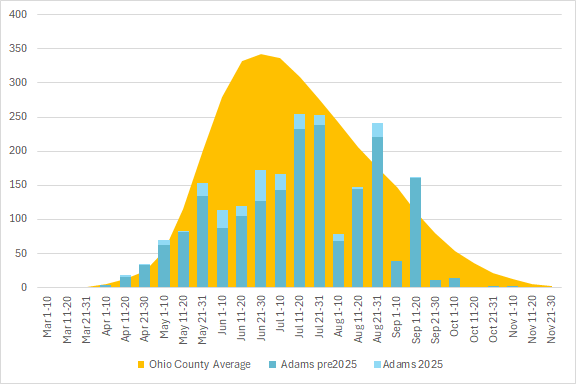
iNaturalist Oda Observation Activity for Adams County
The distance between the blue bars and the gold curve illustrates the relative difference in the cumulative county observations during specific 10-day time slots, and the average number of cumulative observations in those time slots for the entire state.
If the goal of your trip is to continue fleshing out Ohio Dragonfly Survey data, then it would be helpful to concentrate on time periods lower observation activity. If the goal of your trip is to establish new records, visiting the county during periods that have had relatively low levels of observation activity will improve your chances of seeing something that has not been seen before.
Seeking something specific
If you want to find a specific species, perhaps the Gray Petaltail, start with the Species Distribution Maps. Sorted by common name, these charts encapsulate a lot of information to help you with your search

The map not only shows us every county that has had a verified observation, it also indicates which counties had the most recent observations. If your primary goal is to add Gray Petaltail to your lifelist, start looking for suitable observation locations in the darkest counties. Time your search for the first or second weeks of June, which the timeline shows as the peak of the Ohio flight season.
The number of new records, indicated by a white dot, suggests that this species may be expanding its territory or population. If your goal is to expand our knowledge of where this species actually lives and breeds, the empty counties surrounded by counties with recent observations would likely be good starting points. To encourage establishing more county records, the County pages on this site provide Target Species tables listing the species not yet documented in the county that have been observed in adjacent counties since 2000.
Given that it is surrounded by four counties where the species has been sighted, Wayne County might be a starting point. However, a county that is 70% farmland is less likely to host this species than one that is primarily wooded. Before deforestation, the cluster of counties in the southeast under the red oval would have had a significant number of the wooded seeps where petaltail larvae can thrive, as Hocking County does today. Viewable on ODNR’s interactive Mines of Ohio site, much of that region consists of restored strip mines, which along with abandoned farms had trees planted in the mid to late 20th century, and are now reforesting themselves. Is the lack of observed petaltail activity due to the continued habitat unsuitability of these counties, or is it observation bias? The Ohio Counties Compared page can partially answer the latter question. Clicking on the header of the second column to sort it from lowest to highest number of observations makes it clear that Monroe and Noble counties have the two lowest observation counts in the state. Muskingum County has approximately twice as many observations. Whether or not they currently host petaltails, the low observation counties almost certainly offer a relatively high potential for new county records of multiple species.
(See also So you want to get a county record)
Keep an eye on the weather
Don’t begin a multi-hour drive for an oda expedition without first checking the weather. Very few species fly when it is overcast, and virtually no species are active in the rain. However, a sunny morning after a rain can often provide excellent viewing conditions as perched dragonflies dry out and warm up.
Safety Tips
While the rate is much higher in central eastern Ohio, where most Black-legged Ticks have been found, cases of Lyme disease have been documented in almost every county. Compounding the human risk, as existing species expand their territory, new tick species are arriving, and the variety of diseases and health problems associated with tick bites is increasing.
Much of rural Ohio lacks cell coverage, especially in the counties that offer the best potential for new records. CoverageMap provides useful guidance on the liklihood that your destination will have a usable signal, but in low population density locations, reliable service cannot be taken for granted. Consider obtaining a satellite communications device, or one of the newer iPhones with emergency satellite capability. Carry water in your vehicle in case you are stranded overnight.