Monroe County
Known species: 59
Total Observations: 1,113
Population: 14,585
Area in Square Miles: 456
People per Square Mile: 32
Observations per Square Mile: 1.7
Percent of State Species: 34%
Percent of State Observations: 0.4%
County iNaturalist observations
The Observed Species table provides statistical data on all odonata species that have been observed in the county. Below that is a Target Species table listing species that have not yet been documented in this county, but are likely to exist in the county. This list is data-driven by listing species records from neighboring counties.
Observed Species
| Common Name | Scientific Name | Monroe Total | Ohio Total | Monroe 2025 | Last Sighted |
|---|---|---|---|---|---|
| Eastern Pondhawk | Erythemis simplicicollis | 97 | 19,534 | 8 | 2025 |
| Eastern Amberwing | Perithemis tenera | 84 | 12,693 | 5 | 2025 |
| Blue Dasher | Pachydiplax longipennis | 81 | 18,692 | 7 | 2025 |
| Widow Skimmer | Libellula luctuosa | 61 | 14,355 | 7 | 2025 |
| Fragile Forktail | Ischnura posita | 54 | 15,432 | 3 | 2025 |
| Stream Bluet | Enallagma exsulans | 53 | 5,543 | 9 | 2025 |
| Ebony Jewelwing | Calopteryx maculata | 49 | 10,084 | 0 | 2024 |
| Halloween Pennant | Celithemis eponina | 44 | 5,028 | 10 | 2025 |
| Violet Dancer | Argia fumipennis violacea | 43 | 8,693 | 4 | 2025 |
| Slaty Skimmer | Libellula incesta | 33 | 5,911 | 6 | 2025 |
| Double-striped Bluet | Enallagma basidens | 31 | 6,256 | 0 | 2024 |
| Common Whitetail | Plathemis lydia | 29 | 14,243 | 1 | 2025 |
| Black-shouldered Spinyleg | Dromogomphus spinosus | 29 | 763 | 0 | 2024 |
| Powdered Dancer | Argia moesta | 28 | 6,026 | 4 | 2025 |
| Blue-fronted Dancer | Argia apicalis | 27 | 7,716 | 1 | 2025 |
| Skimming Bluet | Enallagma geminatum | 26 | 4,461 | 0 | 2024 |
| Common Sanddragon | Progomphus obscurus | 24 | 171 | 0 | 2024 |
| Blue-tipped Dancer | Argia tibialis | 23 | 5,374 | 2 | 2025 |
| Eastern Forktail | Ischnura verticalis | 23 | 18,549 | 1 | 2025 |
| Banded Pennant | Celithemis fasciata | 22 | 977 | 3 | 2025 |
| Orange Bluet | Enallagma signatum | 21 | 4,380 | 0 | 2023 |
| Spangled Skimmer | Libellula cyanea | 19 | 1,304 | 1 | 2025 |
| Prince Baskettail | Epitheca princeps | 17 | 3,264 | 0 | 2024 |
| American Rubyspot | Hetaerina americana | 16 | 5,250 | 3 | 2025 |
| Dusky Dancer | Argia translata | 15 | 1,962 | 6 | 2025 |
| Black Saddlebags | Tramea lacerata | 12 | 4,110 | 2 | 2025 |
| Swift River Cruiser | Macromia illinoiensis | 12 | 837 | 1 | 2025 |
| Lancet Clubtail | Phanogomphus exilis | 11 | 2,034 | 0 | 2024 |
| Fawn Darner | Boyeria vinosa | 11 | 615 | 0 | 2020 |
| Dragonhunter | Hagenius brevistylus | 10 | 729 | 3 | 2025 |
| Westfall's Slender Bluet | Enallagma traviatum westfalli | 10 | 2,589 | 0 | 2024 |
| Common Baskettail | Epitheca cynosura | 8 | 1,067 | 1 | 2025 |
| Ashy Clubtail | Phanogomphus lividus | 8 | 1,150 | 0 | 2024 |
| Eastern Least Clubtail | Stylogomphus albistylus | 8 | 382 | 0 | 2016 |
| Common Green Darner | Anax junius | 7 | 6,289 | 0 | 2024 |
| Blue-ringed Dancer | Argia sedula | 6 | 3,416 | 2 | 2025 |
| Springtime Darner | Basiaeschna janata | 6 | 466 | 0 | 2019 |
| Familiar Bluet | Enallagma civile | 5 | 7,430 | 1 | 2025 |
| Calico Pennant | Celithemis elisa | 5 | 3,706 | 0 | 2019 |
| Unicorn Clubtail | Arigomphus villosipes | 5 | 2,314 | 0 | 2022 |
| Azure Bluet | Enallagma aspersum | 4 | 2,863 | 0 | 2019 |
| Blue Corporal | Ladona deplanata | 4 | 696 | 0 | 2024 |
| Citrine Forktail | Ischnura hastata | 3 | 1,238 | 1 | 2025 |
| Midland Clubtail | Gomphurus fraternus | 3 | 1,012 | 0 | 2023 |
| Swamp Spreadwing | Lestes vigilax | 3 | 706 | 0 | 2024 |
| Aurora Damsel | Chromagrion conditum | 3 | 706 | 0 | 2019 |
| Autumn Meadowhawk | Sympetrum vicinum | 2 | 10,593 | 0 | 2005 |
| Slender Spreadwing | Lestes rectangularis | 2 | 4,797 | 0 | 2024 |
| Twelve-spotted Skimmer | Libellula pulchella | 2 | 4,080 | 0 | 2017 |
| Dot-tailed Whiteface | Leucorrhinia intacta | 2 | 1,915 | 0 | 2024 |
| Comet Darner | Anax longipes | 2 | 724 | 0 | 2020 |
| Cobra Clubtail | Gomphurus vastus | 2 | 486 | 0 | 2018 |
| Stream Cruiser | Macromia transversa | 2 | 163 | 0 | 2017 |
| Shadow Darner | Aeshna umbrosa | 1 | 1,353 | 0 | 2024 |
| Ruby Meadowhawk | Sympetrum rubicundulum | 1 | 991 | 0 | 2003 |
| Russet-tipped Clubtail | Stylurus plagiatus | 1 | 461 | 0 | 2016 |
| Arrow Clubtail | Stylurus spiniceps | 1 | 341 | 0 | 2021 |
| Green-faced Clubtail | Hylogomphus viridifrons | 1 | 99 | 0 | 1994 |
| Stygian Shadowdragon | Neurocordulia yamaskanensis | 1 | 74 | 0 | 2012 |
Target Species
Target species are potential County Records - species not yet documented in the county. 'Local Obs' is Local Observations and indicates the number of times that the species has been observed in adjacent counties since 2000, and '# of Counties' is the number of adjacent counties in which those recent observations took place. Zero local observations or recent counties means the existing records are historical. 'Peak Active' is a relative description of when the species has been known to fly.| Common Name | Scientific Name | Ohio Obs | Local Obs | # of Counties | Peak Active |
|---|---|---|---|---|---|
| Wandering Glider | Pantala flavescens | 1,903 | 20 | 3 | late Jul-late Aug |
| Carolina Saddlebags | Tramea carolina | 1,444 | 19 | 3 | late May-early Jun |
| Eastern Red Damsel | Amphiagrion saucium | 1,600 | 8 | 2 | late May-early Jun |
| Vesper Bluet | Enallagma vesperum | 999 | 6 | 2 | Jun |
| Spot-winged Glider | Pantala hymenaea | 667 | 4 | 2 | Jul |
| Band-winged Meadowhawk | Sympetrum semicinctum | 1,106 | 2 | 2 | Jul-Aug |
| Smoky Rubyspot | Hetaerina titia | 421 | 33 | 1 | early Sep |
| Royal River Cruiser | Macromia taeniolata | 679 | 6 | 1 | late Jul-Aug |
| Rapids Clubtail | Phanogomphus quadricolor | 445 | 5 | 1 | Jun |
| Turquoise Bluet | Enallagma divagans | 1,043 | 3 | 1 | May-Jun |
| Elegant Spreadwing | Lestes inaequalis | 616 | 2 | 1 | Jun |
| Southern Spreadwing | Lestes australis | 329 | 2 | 1 | May |
| Mocha Emerald | Somatochlora linearis | 263 | 2 | 1 | late Jun-late Aug |
| Uhler's Sundragon | Helocordulia uhleri | 68 | 2 | 1 | May |
| Painted Skimmer | Libellula semifasciata | 1,355 | 1 | 1 | May |
| Great Spreadwing | Archilestes grandis | 1,133 | 1 | 1 | Sep |
| White-faced Meadowhawk | Sympetrum obtrusum | 383 | 1 | 1 | Sep |
| Arrowhead Spiketail | Zoraena obliqua | 207 | 1 | 1 | late May-early Jun |
| Elusive Clubtail | Stylurus notatus | 205 | 1 | 1 | Sep |
| Variegated Meadowhawk | Sympetrum corruptum | 170 | 1 | 1 | Apr-Sep |
| Allegheny River Cruiser | Macromia alleghaniensis | 16 | 1 | 1 | Jul |
| Rainbow Bluet | Enallagma antennatum | 540 | 0 | 0 | Jun |
| Rusty Snaketail | Ophiogomphus rupinsulensis | 428 | 0 | 0 | Jun |
| Green-striped Darner | Aeshna verticalis | 395 | 0 | 0 | Sep |
| Tiger Spiketail | Zoraena erronea | 134 | 0 | 0 | Jul |
| Twin-spotted Spiketail | Zoraena maculata | 99 | 0 | 0 | late May-mid Jun |
| Smoky Shadowdragon | Neurocordulia molesta | 18 | 0 | 0 | Jun |
| Umber Shadowdragon | Neurocordulia obsoleta | 6 | 0 | 0 | Jun |
Monroe County is located along the Ohio River in the Unglaciated Allegheny Plateau.The Little Muskingum River arises in Monroe County, flowing southwesterly through the hills, paralleling the Ohio River and eventually joining it in Washington County.
Places to visit
Over 25,000 acres of the 178,000 acre Wayne National Forest are located in Monroe County
Lamping Homestead Recreation Area has a pond with easy access to about 50% of the perimeter, and it is kayak accessible. It has no drinking water, but the state does provide a rudimentary toilet. $10/night but camping gear needs to be hauled to official sites and distances to those sites will vary. 36 species have been identified.
Ring Mill Campground provides access to a creek. The climb down is medium-hard due to the steep bank. The location is best approached from Rt 68 North. Low Gap Jericho Rd. is often a washout just east of Harmon Ridge on Low Gap requiring 4WD to get through. $10/night to camp but you can park on site.
Knowlton covered bridge provides easy access to the Little Muskingum River. 15 species have been identified.
Monroe Lake is a 39 acre artificial lake within the 1325 acre Monroe Lake Wildlife Area just south of the town of Malaga. The boat launch on the north west side provides easy access to some of the bank, and it is kayak accessible. Take SR 145 to 1001/Main Cross St. The southeast area of the lake provides down to the bank on the dam and around to the north east leg. It can be worth it to walk south down to the dam outlet at the creek. Expect moderate climbs. Parking is located off of SR 800. 27 species have been observed.
Field Trip Guide from 2016 OOS conference
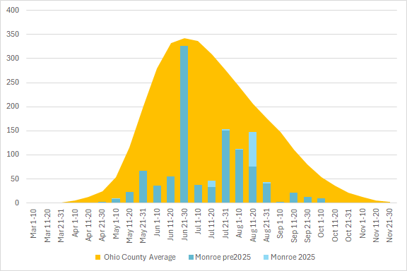
County Observation Activity
This graph shows the total number of odonata observations for the county in blue, with the average for all Ohio counties in orange. The season is divided into 10 or 11 day segments by Month – basically early-month, mid-month, and late-month.
Page updated 25 April 2026