Holmes County
Known species: 70
Total Observations: 1,901
Population: 43,593
Area in Square Miles: 423
People per Square Mile: 103
Observations per Square Mile: 2.3
Percent of State Species: 40%
Percent of State Observations: 0.6%
County iNaturalist observations
The Observed Species table provides statistical data on all odonata species that have been observed in the county. Below that is a Target Species table listing species that have not yet been documented in this county, but are likely to exist in the county. This list is data-driven by listing species records from neighboring counties.
Observed Species
| Common Name | Scientific Name | Holmes Total | Ohio Total | Holmes 2025 | Last Sighted |
|---|---|---|---|---|---|
| Fragile Forktail | Ischnura posita | 220 | 15,432 | 41 | 2025 |
| Blue Dasher | Pachydiplax longipennis | 194 | 18,692 | 41 | 2025 |
| Eastern Pondhawk | Erythemis simplicicollis | 176 | 19,534 | 36 | 2025 |
| Common Whitetail | Plathemis lydia | 98 | 14,243 | 30 | 2025 |
| Smoky Rubyspot | Hetaerina titia | 93 | 421 | 19 | 2025 |
| Eastern Forktail | Ischnura verticalis | 88 | 18,549 | 25 | 2025 |
| Autumn Meadowhawk | Sympetrum vicinum | 82 | 10,593 | 10 | 2025 |
| Eastern Amberwing | Perithemis tenera | 73 | 12,693 | 12 | 2025 |
| Slender Spreadwing | Lestes rectangularis | 72 | 4,797 | 19 | 2025 |
| Widow Skimmer | Libellula luctuosa | 67 | 14,355 | 23 | 2025 |
| Common Green Darner | Anax junius | 66 | 6,289 | 21 | 2025 |
| Ebony Jewelwing | Calopteryx maculata | 66 | 10,084 | 18 | 2025 |
| Blue-fronted Dancer | Argia apicalis | 63 | 7,716 | 26 | 2025 |
| American Rubyspot | Hetaerina americana | 48 | 5,250 | 15 | 2025 |
| Violet Dancer | Argia fumipennis violacea | 36 | 8,693 | 5 | 2025 |
| Familiar Bluet | Enallagma civile | 35 | 7,430 | 6 | 2025 |
| Black Saddlebags | Tramea lacerata | 29 | 4,110 | 20 | 2025 |
| Elegant Spreadwing | Lestes inaequalis | 28 | 616 | 1 | 2025 |
| Blue-tipped Dancer | Argia tibialis | 27 | 5,374 | 10 | 2025 |
| Azure Bluet | Enallagma aspersum | 26 | 2,863 | 16 | 2025 |
| Fawn Darner | Boyeria vinosa | 26 | 615 | 6 | 2025 |
| Twelve-spotted Skimmer | Libellula pulchella | 25 | 4,080 | 11 | 2025 |
| Stream Bluet | Enallagma exsulans | 24 | 5,543 | 9 | 2025 |
| Skimming Bluet | Enallagma geminatum | 23 | 4,461 | 2 | 2025 |
| Orange Bluet | Enallagma signatum | 20 | 4,380 | 2 | 2025 |
| Eastern Red Damsel | Amphiagrion saucium | 13 | 1,600 | 12 | 2025 |
| Wandering Glider | Pantala flavescens | 13 | 1,903 | 9 | 2025 |
| Slaty Skimmer | Libellula incesta | 13 | 5,911 | 2 | 2025 |
| Calico Pennant | Celithemis elisa | 11 | 3,706 | 2 | 2025 |
| Carolina Saddlebags | Tramea carolina | 10 | 1,444 | 5 | 2025 |
| Ruby Meadowhawk | Sympetrum rubicundulum | 10 | 991 | 0 | 2004 |
| Double-striped Bluet | Enallagma basidens | 8 | 6,256 | 3 | 2025 |
| Citrine Forktail | Ischnura hastata | 7 | 1,238 | 4 | 2025 |
| Rainbow Bluet | Enallagma antennatum | 7 | 540 | 4 | 2025 |
| Spot-winged Glider | Pantala hymenaea | 6 | 667 | 4 | 2025 |
| Halloween Pennant | Celithemis eponina | 6 | 5,028 | 1 | 2025 |
| Unicorn Clubtail | Arigomphus villosipes | 6 | 2,314 | 1 | 2025 |
| Midland Clubtail | Gomphurus fraternus | 6 | 1,012 | 0 | 2024 |
| Arrow Clubtail | Stylurus spiniceps | 5 | 341 | 2 | 2025 |
| Shadow Darner | Aeshna umbrosa | 5 | 1,353 | 1 | 2025 |
| Emerald Spreadwing | Lestes dryas | 5 | 708 | 0 | 2024 |
| Comet Darner | Anax longipes | 4 | 724 | 2 | 2025 |
| Prince Baskettail | Epitheca princeps | 4 | 3,264 | 1 | 2025 |
| Powdered Dancer | Argia moesta | 4 | 6,026 | 0 | 2023 |
| Blue-ringed Dancer | Argia sedula | 4 | 3,416 | 0 | 2022 |
| Spatterdock Darner | Rhionaeschna mutata | 3 | 443 | 2 | 2025 |
| Spotted Spreadwing | Lestes congener | 3 | 1,069 | 1 | 2025 |
| Common Baskettail | Epitheca cynosura | 3 | 1,067 | 1 | 2025 |
| Swamp Spreadwing | Lestes vigilax | 3 | 706 | 1 | 2025 |
| Swamp Darner | Epiaeschna heros | 3 | 849 | 0 | 2024 |
| Dragonhunter | Hagenius brevistylus | 3 | 729 | 0 | 1963 |
| Tule Bluet | Enallagma carunculatum | 3 | 685 | 0 | 1936 |
| Rusty Snaketail | Ophiogomphus rupinsulensis | 3 | 428 | 0 | 2007 |
| Painted Skimmer | Libellula semifasciata | 2 | 1,355 | 2 | 2025 |
| Red Saddlebags | Tramea onusta | 2 | 199 | 2 | 2025 |
| Ashy Clubtail | Phanogomphus lividus | 2 | 1,150 | 0 | 1961 |
| Swift River Cruiser | Macromia illinoiensis | 2 | 837 | 0 | 2024 |
| Cobra Clubtail | Gomphurus vastus | 2 | 486 | 0 | 1963 |
| Springtime Darner | Basiaeschna janata | 2 | 466 | 0 | 2024 |
| Lance-tipped Darner | Aeshna constricta | 2 | 363 | 0 | 2024 |
| Twin-spotted Spiketail | Zoraena maculata | 2 | 99 | 0 | 2021 |
| Sweetflag Spreadwing | Lestes forcipatus | 1 | 605 | 1 | 2025 |
| Southern Spreadwing | Lestes australis | 1 | 329 | 1 | 2025 |
| Westfall's Slender Bluet | Enallagma traviatum westfalli | 1 | 2,589 | 0 | 2012 |
| Lancet Clubtail | Phanogomphus exilis | 1 | 2,034 | 0 | 1961 |
| Band-winged Meadowhawk | Sympetrum semicinctum | 1 | 1,106 | 0 | 1958 |
| Royal River Cruiser | Macromia taeniolata | 1 | 679 | 0 | 2022 |
| Gray Petaltail | Tachopteryx thoreyi | 1 | 494 | 0 | 2012 |
| Eastern Least Clubtail | Stylogomphus albistylus | 1 | 382 | 0 | 1993 |
| Dusky Clubtail | Phanogomphus spicatus | 1 | 298 | 0 | 1961 |
Target Species
Target species are potential County Records - species not yet documented in the county. 'Local Obs' is Local Observations and indicates the number of times that the species has been observed in adjacent counties since 2000, and '# of Counties' is the number of adjacent counties in which those recent observations took place. Zero local observations or recent counties means the existing records are historical. 'Peak Active' is a relative description of when the species has been known to fly.| Common Name | Scientific Name | Ohio Obs | Local Obs | # of Counties | Peak Active |
|---|---|---|---|---|---|
| Great Spreadwing | Archilestes grandis | 1,133 | 134 | 5 | Sep |
| Aurora Damsel | Chromagrion conditum | 706 | 115 | 5 | late May-early Jun |
| Dusky Dancer | Argia translata | 1,962 | 109 | 5 | Jul |
| Amber-winged Spreadwing | Lestes eurinus | 759 | 105 | 5 | Jun-Jul |
| Blue-faced Meadowhawk | Sympetrum ambiguum | 1,926 | 84 | 5 | late Aug-mid Sep |
| Dot-tailed Whiteface | Leucorrhinia intacta | 1,915 | 55 | 5 | early Jun |
| Spangled Skimmer | Libellula cyanea | 1,304 | 92 | 4 | Jun |
| Great Blue Skimmer | Libellula vibrans | 513 | 29 | 4 | Jun-Jul |
| Vesper Bluet | Enallagma vesperum | 999 | 21 | 4 | Jun |
| Sedge Sprite | Nehalennia irene | 414 | 16 | 4 | Jun |
| Plains Clubtail | Gomphurus externus | 244 | 178 | 3 | mid Jun-mid Jul |
| Green-striped Darner | Aeshna verticalis | 395 | 30 | 3 | Sep |
| Four-spotted Skimmer | Libellula quadrimaculata | 297 | 29 | 3 | Jun |
| Black-tipped Darner | Aeshna tuberculifera | 181 | 27 | 3 | late Aug-early Sep |
| Cyrano Darner | Nasiaeschna pentacantha | 366 | 23 | 3 | mid Jun |
| Clamp-tipped Emerald | Somatochlora tenebrosa | 251 | 19 | 3 | Aug |
| Sphagnum Sprite | Nehalennia gracilis | 514 | 188 | 2 | late Jun-early Jul |
| Lilypad Forktail | Ischnura kellicotti | 961 | 148 | 2 | Jun-Sep |
| Turquoise Bluet | Enallagma divagans | 1,043 | 70 | 2 | May-Jun |
| Mocha Emerald | Somatochlora linearis | 263 | 17 | 2 | late Jun-late Aug |
| Rapids Clubtail | Phanogomphus quadricolor | 445 | 14 | 2 | Jun |
| Black-shouldered Spinyleg | Dromogomphus spinosus | 763 | 5 | 2 | Jun-Jul |
| Variegated Meadowhawk | Sympetrum corruptum | 170 | 2 | 2 | Apr-Sep |
| Tiger Spiketail | Zoraena erronea | 134 | 2 | 2 | Jul |
| Macromia Hybrid | Macromia pacifica x taeniolata | 110 | 2 | 2 | late Jul-mid Aug |
| Seepage Dancer | Argia bipunctulata | 1,464 | 44 | 1 | Jun-Jul |
| Laura's Clubtail | Stylurus laurae | 52 | 20 | 1 | late Jul-early Sep |
| White-faced Meadowhawk | Sympetrum obtrusum | 383 | 6 | 1 | Sep |
| Banded Pennant | Celithemis fasciata | 977 | 4 | 1 | Jul |
| Flag-tailed Spinyleg | Dromogomphus spoliatus | 939 | 3 | 1 | late Jul |
| Lyre-tipped Spreadwing | Lestes unguiculatus | 247 | 3 | 1 | Jun-Jul |
| Blue Corporal | Ladona deplanata | 696 | 2 | 1 | May |
| Gilded River Cruiser | Macromia pacifica | 92 | 2 | 1 | late Jul |
| Racket-tailed Emerald | Dorocordulia libera | 66 | 2 | 1 | Jun |
| Pronghorn Clubtail | Phanogomphus graslinellus | 566 | 1 | 1 | late May-early Jun |
| Handsome Clubtail | Gomphurus crassus | 226 | 1 | 1 | late May-early Jun |
| Arrowhead Spiketail | Zoraena obliqua | 207 | 1 | 1 | late May-early Jun |
| Delta-spotted Spiketail | Zoraena diastatops | 150 | 1 | 1 | early Jun |
| Green-faced Clubtail | Hylogomphus viridifrons | 99 | 1 | 1 | mid Jun |
| Wabash River Cruiser | Macromia wabashensis | 25 | 1 | 1 | Aug |
| Brush-tipped Emerald | Somatochlora walshii | 23 | 1 | 1 | mid Jun-mid Jul |
| River Bluet | Enallagma anna | 21 | 1 | 1 | Jun |
| Cherry-faced Meadowhawk | Sympetrum internum | 14 | 1 | 1 | Sep |
| Furtive Forktail | Ischnura prognata | 4 | 1 | 1 | |
| Elusive Clubtail | Stylurus notatus | 205 | 0 | 0 | Sep |
| Splendid Clubtail | Gomphurus lineatifrons | 141 | 0 | 0 | Jun |
| Hagen's Bluet | Enallagma hageni | 85 | 0 | 0 | Jun |
| Stygian Shadowdragon | Neurocordulia yamaskanensis | 74 | 0 | 0 | late Jun |
| Marsh Bluet | Enallagma ebrium | 66 | 0 | 0 | mid Jun |
| Riffle Snaketail | Ophiogomphus carolus | 64 | 0 | 0 | mid Jun |
| Skillet Clubtail | Gomphurus ventricosus | 26 | 0 | 0 | Jun |
| Northern Spreadwing | Lestes disjunctus | 24 | 0 | 0 | Jun-Aug |
| Saffron-winged Meadowhawk | Sympetrum costiferum | 20 | 0 | 0 | Oct |
| Smoky Shadowdragon | Neurocordulia molesta | 18 | 0 | 0 | Jun |
| Northern Pygmy Clubtail | Lanthus parvulus | 7 | 0 | 0 | Jun |
| Appalachian Jewelwing | Calopteryx angustipennis | 4 | 0 | 0 | |
| Spine-crowned Clubtail | Hylogomphus abbreviatus | 3 | 0 | 0 | Jun |
Located in the Allegheny Plateau, the terminal moraine divides Holmes County in half, reaching its maximum southern extent in the Killbuck Valley, just south of the county seat of Millersburg. The lower half of the relatively small Lake Fork Mohican River (302.1 cu ft/second) flows through the northwestern corner of the county, intersecting the Mohican River, which flows several miles through the southeast corner of the county. The most significant waterway in the county is the Killbuck Creek, which cuts the county in half north to south. The Doughty Creek, flowing SE from Berlin and joining the Killbuck several miles south of the Holmes Coshocton line is the largest waterway in the eastern half of the county (no public access other than bridges). The Killbuck Valley between Wooster (Wayne County) and Layland (just south of the Coshocton County line) benefits from silt, sand, and gravel deposited by glacial outwash. Originally a huge marshland, much of it was drained in the late 19th and early 20th century, but continued flooding has discouraged farming, rail, and roads, and after WWII, much of this area has been reverting to marshland. The glaciated northern half of the county is dominated by small family farms, many of them Amish, while much of the southern half, in the Unglaciated Allegheny Plateau, is wooded. (see Muskingum River Watershed)
Places to Visit
Holmes County has relatively little publicly accessible land, virtually all of which is in the Killbuck Valley.
Most of the 5,700 acre Killbuck Marsh Wildlife Area is located in Wayne County, but the property extends all the way south to Holmesville (3.8 miles). The best access is just south of the county line, east of SR 83, on CR 1, which provides access to the Killbuck Creek, a small pond, and marshland along both sides of CR 1. Be aware that the area between CR 1 and Force Road (Wayne County) is a wildlife Refuge area and is closed to the public. The ODNR does provide some parking areas, but otherwise, the Holmes section of the Wildlife Area is totally unimproved, with no maintained trails and no facilities.
The Killbuck Watershed Land Trust, in conjunction with the Arc of Appalachia, owns multiple pieces of Holmes county property starting just north of Killbuck, and extending through the Killbuck Valley to just past the Coshocton County line. Collectively referred to as the Killbuck Swamp Preserve, 36 odonata species have been observed. All of the land north of SR62 is open to public access. Trails and parking improvement are rudimentary, but improvements are underway. This land is not well documented on their web site, and a property map application like onX Hunt is recommended
Baker Swamp is located just north of the Holmes County Trail. Park at the trailhead parking lot just east of Killbuck on County 622. All of the land north of the trail, starting just west of the power substation and east to Township 91 belongs to the trust. Walk east on the paved trail to TR 91 to access Killbuck Creek (see interactive map above).
Turtle Pond is an 80 acre wetland immediately east of the village of Killbuck, between Killbuck Creek, County 621, and SR 520. A small parking area on 621 just west of the bridge provides access to a 600 yard gravel walking path between the river and marsh. River access is being improved through a kayak launch site, and a boardwalk is planned to run parallel to the county road. A second parking spot at the intersection of Holmes 621 and SR 520 (10114 OH-520, Killbuck, OH 44637) provides access to a wooded hillside and the NW corner of the wetland (see interactive map above). The gas station in Killbuck has restrooms.
Restoration of the 194 acre Crane Swamp property, including the rewilding of Laurel Creek, and the 90 acre Bowfin Bottoms on the Holmes/Coshocton line is underway in early 2026, and is not currently open to the public.
Legacy Point Park, a former landfill that includes multiple ponds, was opened in 2025. 24 species have been observed.
Mohican State Scenic River Designation Study. This is a 55 page ODNR analysis of the Clear Fork/Mohican River created in 2006 leading up to its inclusion into Ohio’s Scenic Rivers System. It provides an overview of the human and natural histories of the Mohican River and its tributary creeks, and includes detailed maps. There is no public access to the Mohican in Holmes County, but a number of small bridges provide some visibility into the Lake Fork Mohican tributary.
Mohican River Water Trail Guide from ODNR.
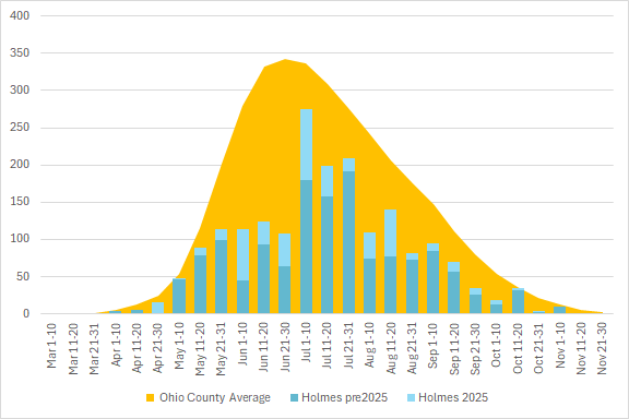
County Observation Activity
This graph shows the total number of odonata observations for the county in blue, with the average for all Ohio counties in orange. The season is divided into 10 or 11 day segments by Month – basically early-month, mid-month, and late-month.
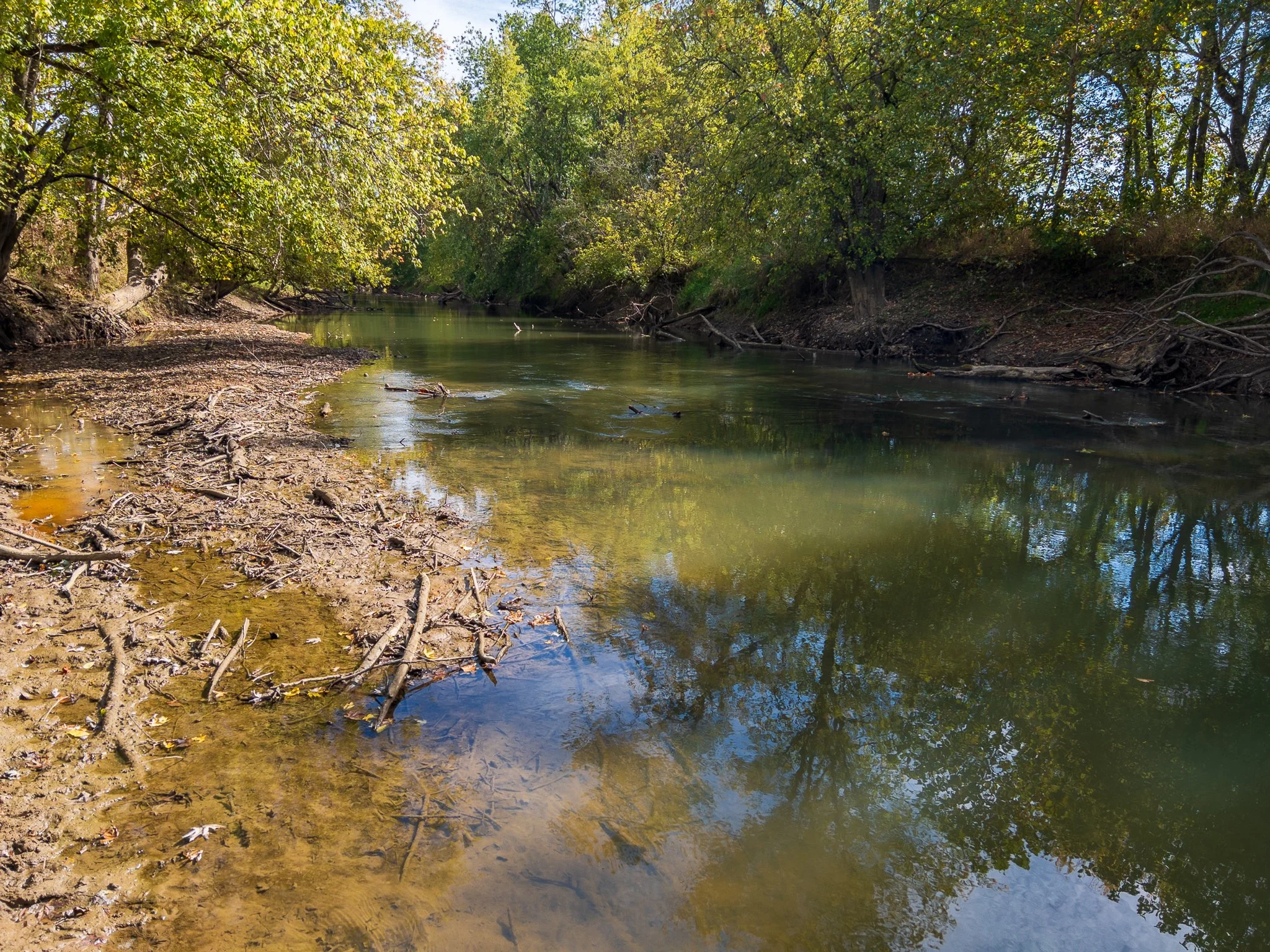
The muddy and wooded Killbuck Creek is an ideal habitat for Smoky RubyspotsPage updated 12 January 2026